File:Vermilion wabashrivermap.png

Cabirka muuqaalkaan: 600 × 600 pixels. Waxyaabaha kale xalinta: 240 × 240 pixels | 480 × 480 pixels | 1,000 × 1,000 pixels.
Faylka asalka ah (1,000 × 1,000 pixels, weyninka faylka : 554 KB, nuuca MIME: image/png)
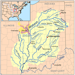
| Sharaxaad | Map of the Wabash River watershed with the Vermilion River highlighted (including the Salt, Middle, and North forks). |
| Taariikhda | |
| Xigasho | Self-made, based on USGS data. |
| Qoraa | Kmusser |
I, the copyright holder of this work, hereby publish it under the following license:
This file is licensed under the Creative Commons Attribution-Share Alike 3.0 Unported license.
- Waad fasaxantahay:
- la wadaagid – koobi gareenta, qaybinta iyo gudbinta shaqada
- to remix – in shaqada la waafajiyo
- Shuruudaha soo socda:
- Astaan – You must give appropriate credit, provide a link to the license, and indicate if changes were made. You may do so in any reasonable manner, but not in any way that suggests the licensor endorses you or your use.
- si isku mid la wadaag – If you remix, transform, or build upon the material, you must distribute your contributions under the same or compatible license as the original.
Taariikhda faylka
Riix taariikhda/waqtiga si aad u argto faylka sida oo ahaa markiisa hore.
| Taariikhda/Waqtiga | Sawir yar | Cabirka | Isticmaale | Ka hadalka | |
|---|---|---|---|---|---|
| kan hadda | 19:45, 3 Juun 2008 | | 1,000 × 1,000 (554 KB) | Kmusser | {{Information |Description=Map of the Wabash River watershed with the Vermilion River highlighted. |Source=Self-made, based on USGS data. |Date=June 3, 2008 |Author= [[User |
Faylka lagu isticmaalay
waxyaabaha soo socda ee bog ayaa adeegsanaya faylkaan:
isticmaalka faylka aduunka
Wikisyada kale ee soosocda ayaa adeegsanaya faylka:
- Ku isticmaal af.wikipedia.org
- Ku isticmaal ar.wikipedia.org
- Ku isticmaal arz.wikipedia.org
- Ku isticmaal de.wikipedia.org
- Ku isticmaal el.wikipedia.org
- Ku isticmaal en.wikipedia.org
- Ku isticmaal fr.wikipedia.org
- Ku isticmaal ja.wikipedia.org
- Ku isticmaal kab.wikipedia.org
- Ku isticmaal www.wikidata.org
- Ku isticmaal xmf.wikipedia.org
- Ku isticmaal zh.wikipedia.org