File:Benuerivermap.png
Cabirka muuqaalkaan: 600 × 600 pixels. Waxyaabaha kale xalinta: 240 × 240 pixels | 480 × 480 pixels | 1,000 × 1,000 pixels.
Faylka asalka ah (1,000 × 1,000 pixels, weyninka faylka : 1.51 MB, nuuca MIME: image/png)
Qoraal kooban
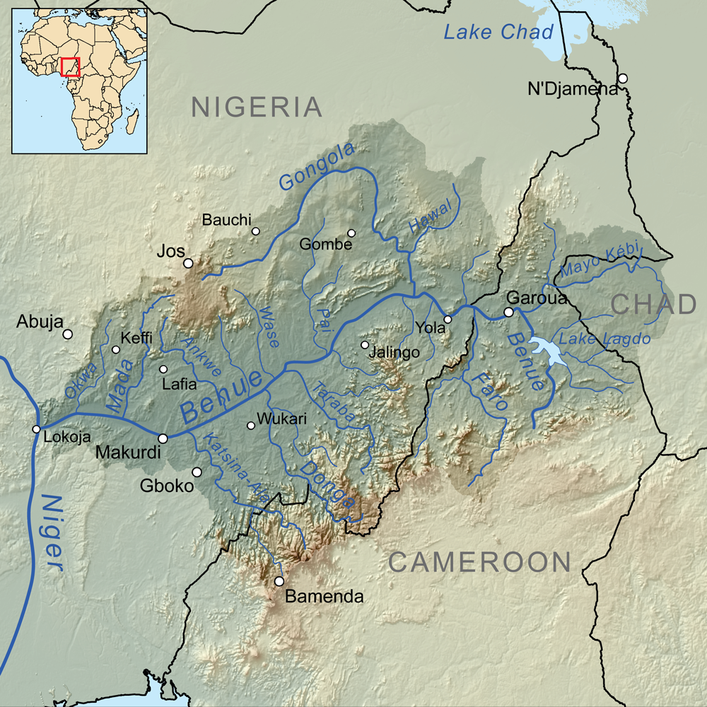
| Sharaxaad | Map showing the Benue River drainage basin. |
| Taariikhda | |
| Xigasho | Shaqadayda, Elevation data from SRTM, drainage basin from GTOPO [1], all other features from Vector Map. |
| Qoraa | Kmusser |
Laysinka
I, the copyright holder of this work, hereby publish it under the following license:
This file is licensed under the Creative Commons Attribution-Share Alike 3.0 Unported license.
- Waad fasaxantahay:
- la wadaagid – koobi gareenta, qaybinta iyo gudbinta shaqada
- to remix – in shaqada la waafajiyo
- Shuruudaha soo socda:
- Astaan – You must give appropriate credit, provide a link to the license, and indicate if changes were made. You may do so in any reasonable manner, but not in any way that suggests the licensor endorses you or your use.
- si isku mid la wadaag – If you remix, transform, or build upon the material, you must distribute your contributions under the same or compatible license as the original.
Taariikhda faylka
Riix taariikhda/waqtiga si aad u argto faylka sida oo ahaa markiisa hore.
| Taariikhda/Waqtiga | Sawir yar | Cabirka | Isticmaale | Ka hadalka | |
|---|---|---|---|---|---|
| kan hadda | 16:00, 8 Oktoobar 2010 | | 1,000 × 1,000 (1.51 MB) | Kmusser | +Wukari |
| 16:06, 7 Abriil 2010 |  | 1,000 × 1,000 (1.63 MB) | Kmusser | +N'Djamena | |
| 16:02, 7 Abriil 2010 |  | 1,000 × 1,000 (1.63 MB) | Kmusser | Flip basin highlighting | |
| 15:35, 1 Abriil 2010 |  | 1,000 × 1,000 (1.51 MB) | Kmusser | == Summary == {{Information |Description=Map showing the Benue River drainage basin. |Source={{own}}, Elevation data from SRTM, drainage basin from GTOPO [http://eros.usgs.gov/#/Find_Data/Products |
Faylka lagu isticmaalay
waxyaabaha soo socda ee bog ayaa adeegsanaya faylkaan:
isticmaalka faylka aduunka
Wikisyada kale ee soosocda ayaa adeegsanaya faylka:
- Ku isticmaal af.wikipedia.org
- Ku isticmaal ar.wikipedia.org
- Ku isticmaal arz.wikipedia.org
- Ku isticmaal ast.wikipedia.org
- Ku isticmaal ba.wikipedia.org
- Ku isticmaal be.wikipedia.org
- Ku isticmaal bg.wikipedia.org
- Ku isticmaal bs.wikipedia.org
- Ku isticmaal ca.wikipedia.org
- Ku isticmaal cs.wikipedia.org
- Ku isticmaal da.wikipedia.org
- Ku isticmaal de.wikipedia.org
- Ku isticmaal el.wikipedia.org
- Ku isticmaal en.wikipedia.org
- Ku isticmaal eo.wikipedia.org
- Ku isticmaal es.wikipedia.org
- Ku isticmaal eu.wikipedia.org
- Ku isticmaal fi.wikipedia.org
- Ku isticmaal fr.wikipedia.org
- Ku isticmaal fy.wikipedia.org
- Ku isticmaal gl.wikipedia.org
- Ku isticmaal ha.wikipedia.org
View more global usage of this file.