File:Scotland topographic map-en.jpg
Cabirka muuqaalkaan: 417 × 599 pixels. Waxyaabaha kale xalinta: 167 × 240 pixels | 334 × 480 pixels | 534 × 768 pixels | 712 × 1,024 pixels | 2,400 × 3,450 pixels.
Faylka asalka ah (2,400 × 3,450 pixels, weyninka faylka : 2.29 MB, nuuca MIME: image/jpeg)
Qoraal kooban
| Camera location | | View this and other nearby images on: OpenStreetMap |
|---|
| Sharaxaad |
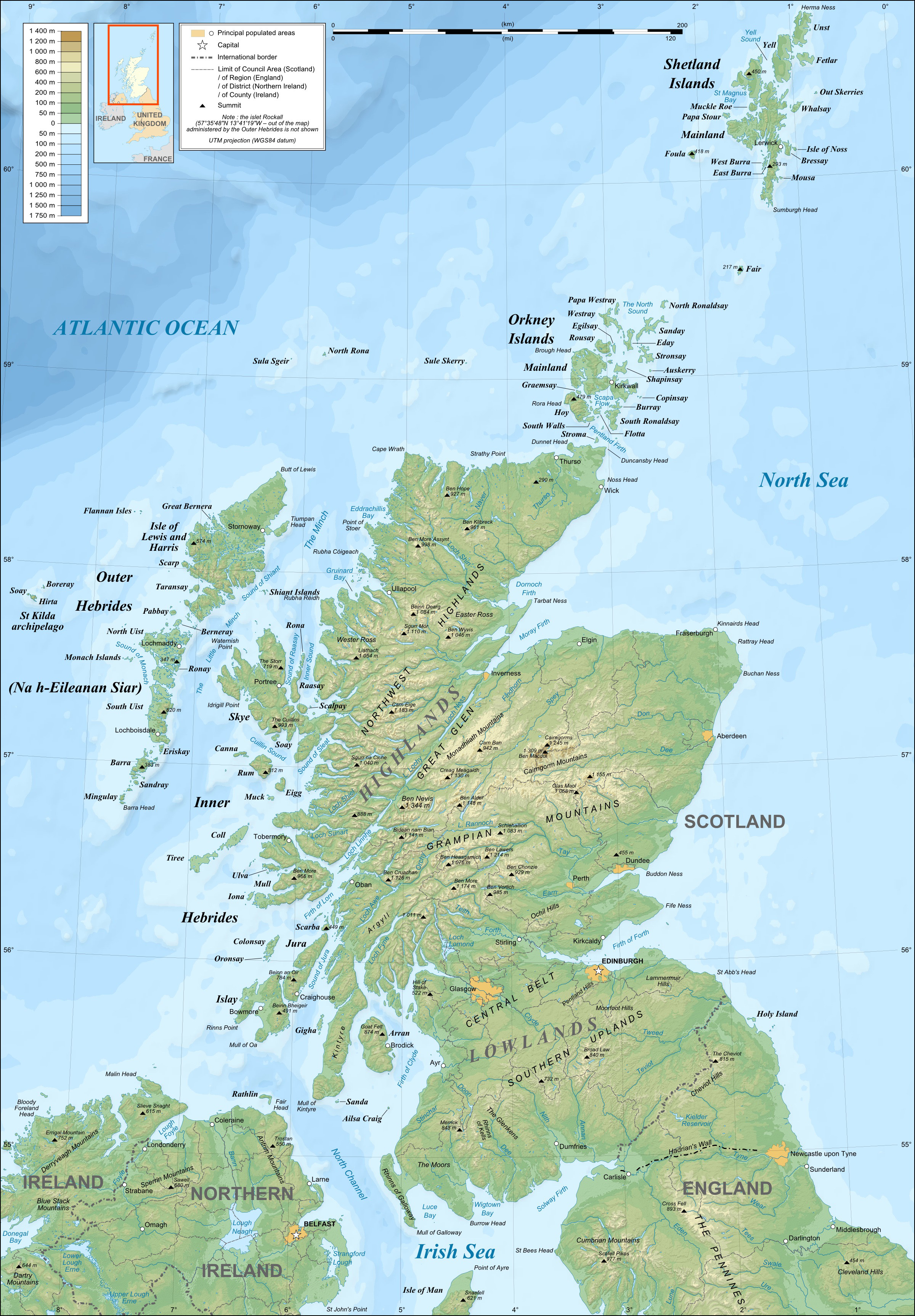
English: Topographic map in English of Scotland
This is a lighter raster JPG format version of Image:Scotland_topographic_map-en.svg which should be used in the article pages, the vector graphics version purpose being for modification and / or translation. Français : Carte topographique en anglais de l'Écosse.
Ceci est une version bitmap au format JPG et de poids de fichier plus léger de Image:Scotland_topographic_map-fr.svg qui devrait être utilisée dans les pages d'articles, la version vectorisée SVG étant destinée à faciliter les modifications et / ou traductions.
|
||
| Taariikhda | December 2007 (modified 09-2008) | ||
| Xigasho |
Own work ;
|
||
| Qoraa | Eric Gaba (Sting – fr:Sting) | ||
| Ogolaasho (Dib u isticmaalka faylkaan) |
|
||
| Other versions |
Derivative works of this file: River Forth course 3.png
[]
|


Laysinka
I, the copyright holder of this work, hereby publish it under the following licenses:

|
Permission is granted to copy, distribute and/or modify this document under the terms of the GNU Free Documentation License, Version 1.2 or any later version published by the Free Software Foundation; with no Invariant Sections, no Front-Cover Texts, and no Back-Cover Texts. A copy of the license is included in the section entitled GNU Free Documentation License. |
This file is licensed under the Creative Commons Attribution-Share Alike 4.0 International, 3.0 Unported, 2.5 Generic, 2.0 Generic and 1.0 Generic license.
- Waad fasaxantahay:
- la wadaagid – koobi gareenta, qaybinta iyo gudbinta shaqada
- to remix – in shaqada la waafajiyo
- Shuruudaha soo socda:
- Astaan – You must give appropriate credit, provide a link to the license, and indicate if changes were made. You may do so in any reasonable manner, but not in any way that suggests the licensor endorses you or your use.
- si isku mid la wadaag – If you remix, transform, or build upon the material, you must distribute your contributions under the same or compatible license as the original.
You may select the license of your choice.
Taariikhda faylka
Riix taariikhda/waqtiga si aad u argto faylka sida oo ahaa markiisa hore.
| Taariikhda/Waqtiga | Sawir yar | Cabirka | Isticmaale | Ka hadalka | |
|---|---|---|---|---|---|
| kan hadda | 21:41, 17 Luuliyo ama Luulyo 2010 | | 2,400 × 3,450 (2.29 MB) | Sting | Color profile |
| 23:35, 24 Sebteembar 2008 |  | 2,400 × 3,450 (1.99 MB) | Sting | Completely new background : raster topography and using ETOPO1 data for bathymetry ; new standard colors | |
| 01:02, 14 Diseembar 2007 |  | 2,400 × 3,450 (2.12 MB) | Sting | Additional name | |
| 20:55, 12 Diseembar 2007 |  | 2,400 × 3,450 (2.12 MB) | Sting | Correction in key | |
| 16:18, 12 Diseembar 2007 |  | 2,400 × 3,450 (2.12 MB) | Sting | {{Location|57|00|00|N|04|00|00|W|scale:4000000}} <br/> {{Information |Description=Topographic map in English of Scotland<br/>This is a lighter raster JPG format version of Image:Scotland_topographic_map-en.svg which should be used in |
Faylka lagu isticmaalay
waxyaabaha soo socda ee bog ayaa adeegsanaya faylkaan:
isticmaalka faylka aduunka
Wikisyada kale ee soosocda ayaa adeegsanaya faylka:
- Ku isticmaal en.wikipedia.org
- Ku isticmaal es.wikipedia.org
- Ku isticmaal ga.wiktionary.org
- Ku isticmaal gd.wikipedia.org
- Ku isticmaal hu.wikipedia.org
- Ku isticmaal id.wikipedia.org
- Ku isticmaal lt.wikipedia.org
- Ku isticmaal to.wikipedia.org
- Ku isticmaal uk.wikipedia.org