File:New Brunswick topographic map-fr.svg

Size of this PNG preview of this SVG file: 610 × 600 pixels. Waxyaabaha kale xalinta: 244 × 240 pixels | 488 × 480 pixels | 781 × 768 pixels | 1,042 × 1,024 pixels | 2,083 × 2,048 pixels | 2,237 × 2,199 pixels.
Faylka asalka ah (SVG file, nominally 2,237 × 2,199 pixels, file size: 3.31 MB)
Qoraal kooban
| Sharaxaad |
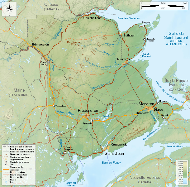
English: General map of New Brunswick, Canada, with topographic bakground (embeded raster file). French version.
Equirectangular projection, WGS84 datum
Geographic limits of the map:
Français : Carte générale du Nouveau-Brunswick, Canada, avec un fond topographique (fichier matriciel incorporé). Version en français.
Projection équirectangulaire, système géodétique WGS84.
Limites géographiques de la carte :
|
||
| Taariikhda | |||
| Xigasho |
Shaqadayda. English:
Français : |
||
| Qoraa | Sémhur (talk) | ||
| Other versions | |||
| Attribution (required by the license) | © Sémhur / Wikimedia Commons / | ||
| SVG | W3C-validity not checked.
|
||
| Graphic Lab |

| Camera location | | View this and other nearby images on: OpenStreetMap |
|---|
Laysinka
I, the copyright holder of this work, hereby publish it under the following licenses:
| Copyleft: This work of art is free; you can redistribute it and/or modify it according to terms of the Free Art License. You will find a specimen of this license on the Copyleft Attitude site as well as on other sites. |
This file is licensed under the Creative Commons Attribution-Share Alike 4.0 International, 3.0 Unported, 2.5 Generic, 2.0 Generic and 1.0 Generic license.
- Waad fasaxantahay:
- la wadaagid – koobi gareenta, qaybinta iyo gudbinta shaqada
- to remix – in shaqada la waafajiyo
- Shuruudaha soo socda:
- Astaan – You must give appropriate credit, provide a link to the license, and indicate if changes were made. You may do so in any reasonable manner, but not in any way that suggests the licensor endorses you or your use.
- si isku mid la wadaag – If you remix, transform, or build upon the material, you must distribute your contributions under the same or compatible license as the original.
You may select the license of your choice.
Taariikhda faylka
Riix taariikhda/waqtiga si aad u argto faylka sida oo ahaa markiisa hore.
| Taariikhda/Waqtiga | Sawir yar | Cabirka | Isticmaale | Ka hadalka | |
|---|---|---|---|---|---|
| kan hadda | 07:06, 23 Mey 2014 | | 2,237 × 2,199 (3.31 MB) | Sémhur | Valid SVG |
| 21:18, 29 Nofeembar 2011 |  | 2,237 × 2,199 (3.31 MB) | Sémhur | == {{int:filedesc}} == {{Information |Description={{Multilingual description |en=General map of New Brunswick, Canada, with topographic bakground (embeded raster file). French version. Equirectangular projection, WGS84 datum *Standa |
Faylka lagu isticmaalay
Ma jiraan bogag adeegsanaya faylkaan.
isticmaalka faylka aduunka
Wikisyada kale ee soosocda ayaa adeegsanaya faylka:
- Ku isticmaal bn.wikipedia.org
- Ku isticmaal en.wikipedia.org
- Ku isticmaal fr.wikipedia.org
- Ku isticmaal hu.wikipedia.org
- Ku isticmaal id.wikipedia.org
- Ku isticmaal incubator.wikimedia.org
- Ku isticmaal kk.wikipedia.org