File:Middle East Shem-Ham.jpg

Faylka asalka ah (1,000 × 895 pixels, weyninka faylka : 823 KB, nuuca MIME: image/jpeg)
Qoraal kooban
| Sharaxaad |
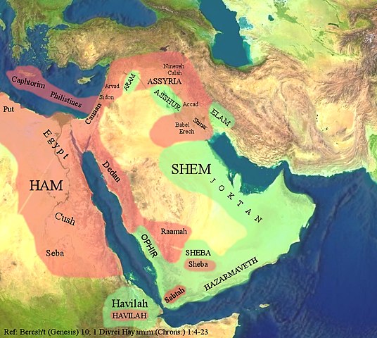
The Middle East through the eyes of the Ancient Israelites. العربية: الشرق الأوسط بعيون الإسرائيليين القدماء. |
| Taariikhda | |
| Xigasho |
The background image is based on the satellite image of the Middle East in the public domain from a screenshot from NASA’s globe software World Wind using Blue Marble, Landsat or USGS layer, all of which are in public domain. The geographical location of the place names and color highlights of Ham and Shem are based on the work of 4(four) Israeli Archaeologists: Yohanan Aharoni, Michael Avi-Yonah, Anson F. Rainey, and Ze’ev Safrai, The Macmillan Bible Atlas, Macmillan Publishing: New York, 1993, p. 21. |
| Qoraa | Hkp-avniel 15:50, 22 March 2008 (UTC) |
| Other versions | العربيَّة |
Laysinka

|
Permission is granted to copy, distribute and/or modify this document under the terms of the GNU Free Documentation License, Version 1.2 or any later version published by the Free Software Foundation; with no Invariant Sections, no Front-Cover Texts, and no Back-Cover Texts. A copy of the license is included in the section entitled GNU Free Documentation License. |
- Waad fasaxantahay:
- la wadaagid – koobi gareenta, qaybinta iyo gudbinta shaqada
- to remix – in shaqada la waafajiyo
- Shuruudaha soo socda:
- Astaan – You must give appropriate credit, provide a link to the license, and indicate if changes were made. You may do so in any reasonable manner, but not in any way that suggests the licensor endorses you or your use.
- si isku mid la wadaag – If you remix, transform, or build upon the material, you must distribute your contributions under the same or compatible license as the original.
Taariikhda faylka
Riix taariikhda/waqtiga si aad u argto faylka sida oo ahaa markiisa hore.
| Taariikhda/Waqtiga | Sawir yar | Cabirka | Isticmaale | Ka hadalka | |
|---|---|---|---|---|---|
| kan hadda | 15:53, 22 Maaj 2008 | | 1,000 × 895 (823 KB) | Hkp-avniel | {{Information |Description= |Source= |Date= |Author= |Permission= |other_versions= }} |
| 11:06, 22 Maaj 2008 |  | 1,000 × 895 (825 KB) | Hkp-avniel | {{Information |Description= The Middle East through the eyes of the Ancient Israelites. |Source= The background image is based on the satellite image of the Middle East in the public domain from a screenshot from NASA’s globe software World Wind using B |
Faylka lagu isticmaalay
waxyaabaha soo socda ee bog ayaa adeegsanaya faylkaan:
isticmaalka faylka aduunka
Wikisyada kale ee soosocda ayaa adeegsanaya faylka:
- Ku isticmaal ar.wikipedia.org
- Ku isticmaal bs.wikipedia.org
- Ku isticmaal ca.wikipedia.org
- Ku isticmaal cs.wikipedia.org
- Ku isticmaal en.wikipedia.org
- Ku isticmaal fi.wikipedia.org
- Ku isticmaal fr.wikipedia.org
- Ku isticmaal he.wikipedia.org
- Ku isticmaal lt.wikipedia.org
- Ku isticmaal pnb.wikipedia.org
- Ku isticmaal pt.wikipedia.org
- Ku isticmaal ro.wikipedia.org
- Ku isticmaal uk.wikipedia.org
- Ku isticmaal zh.wikipedia.org