File:Map Seoul districts de.png
Cabirka muuqaalkaan: 600 × 600 pixels. Waxyaabaha kale xalinta: 240 × 240 pixels | 480 × 480 pixels | 768 × 768 pixels | 1,024 × 1,024 pixels | 2,048 × 2,048 pixels | 2,760 × 2,760 pixels.
Faylka asalka ah (2,760 × 2,760 pixels, weyninka faylka : 191 KB, nuuca MIME: image/png)
Fotowerkstatt
This picture was reworked by the Fotowerkstatt. You can propose images to improve as well.
| Sharaxaad |
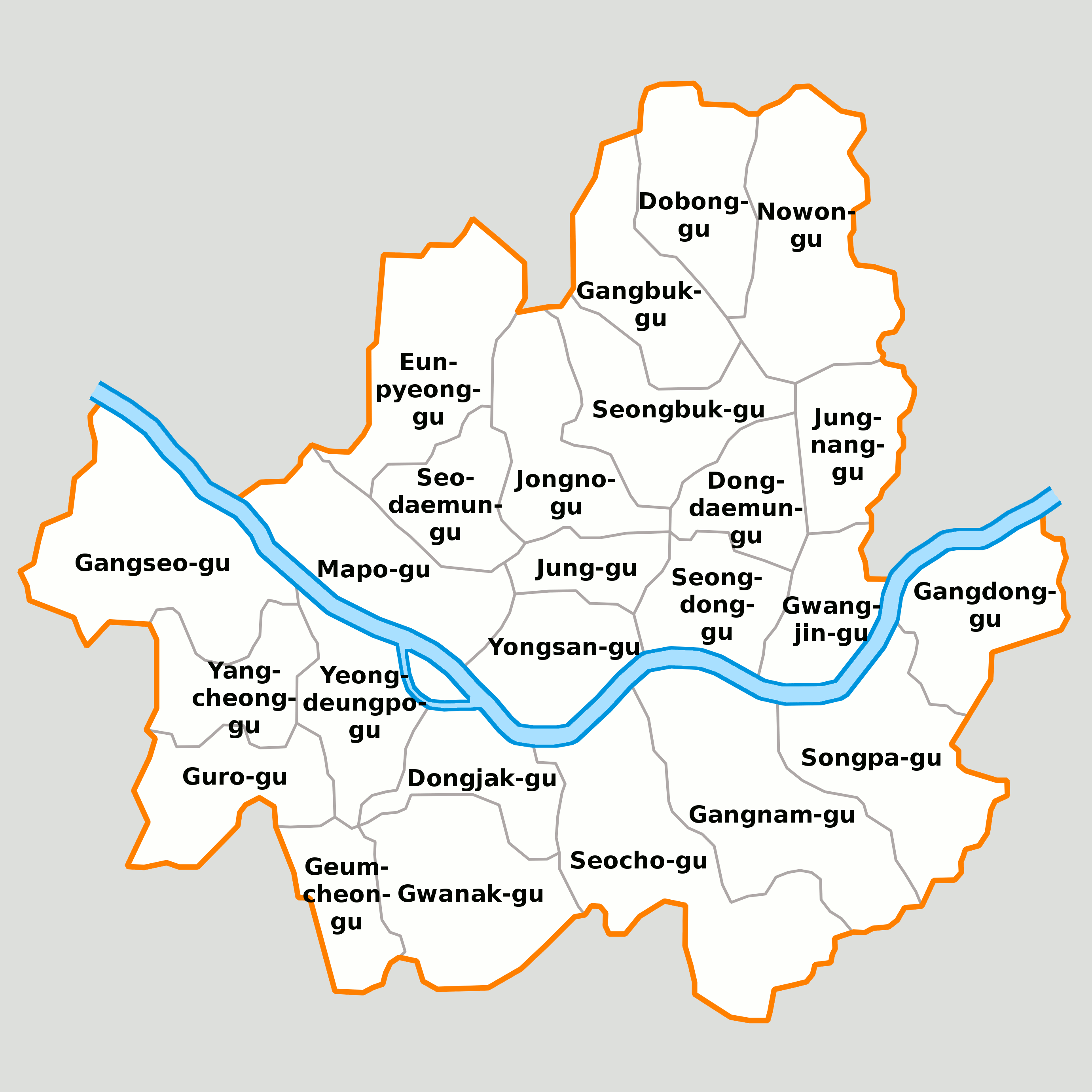
English: Districts of Seoul with romanizied labels
Deutsch: Karte von Seoul |
||||||||
| Taariikhda | 04.10.2005 | ||||||||
| Xigasho | Shaqadayda Ralf, Stefan-Xp, iGEL | ||||||||
| Qoraa | dxf-Data by Ralf, png by Stefan-Xp, labels by iGEL | ||||||||
| Ogolaasho (Dib u isticmaalka faylkaan) |
Wikipedia (benutzer:ralf roletschek) user [[:Benutzer:Ralf Roletschek:User:{{{3}}}|{{{3}}}]], the copyright holder of this work, hereby publishes it under the following license:
|
||||||||
| Other versions |
|


Taariikhda faylka
Riix taariikhda/waqtiga si aad u argto faylka sida oo ahaa markiisa hore.
| Taariikhda/Waqtiga | Sawir yar | Cabirka | Isticmaale | Ka hadalka | |
|---|---|---|---|---|---|
| kan hadda | 02:43, 8 Oktoobar 2005 | | 2,760 × 2,760 (191 KB) | IGEL | Labels moved a little bit |
| 02:36, 8 Oktoobar 2005 |  | 2,760 × 2,760 (192 KB) | IGEL | Destricts of Seoul with German labels Other versions: Image:Image-Map Seoul-teukbyeolsi-big.png, Image:Map Seoul-teukbyeolsi.png Authors: de:Benutzer:Ralf Roletschek, User:Stefan-Xp, ~~~ |
Faylka lagu isticmaalay
Ma jiraan bogag adeegsanaya faylkaan.
isticmaalka faylka aduunka
Wikisyada kale ee soosocda ayaa adeegsanaya faylka:
- Ku isticmaal af.wikipedia.org
- Ku isticmaal ar.wikipedia.org
- Ku isticmaal ba.wikipedia.org
- Ku isticmaal bg.wikipedia.org
- Ku isticmaal bs.wikipedia.org
- Ku isticmaal ca.wikipedia.org
- Ku isticmaal cs.wikipedia.org
- Ku isticmaal cy.wikipedia.org
- Ku isticmaal da.wikipedia.org
- Ku isticmaal de.wikipedia.org
- Ku isticmaal de.wikivoyage.org
- Ku isticmaal en.wikivoyage.org
- Ku isticmaal eo.wikipedia.org
- Ku isticmaal es.wikipedia.org
- Ku isticmaal et.wikipedia.org
- Ku isticmaal eu.wikipedia.org
- Ku isticmaal fi.wikipedia.org
- Ku isticmaal fo.wikipedia.org
- Ku isticmaal fr.wikipedia.org
- Ku isticmaal hr.wikipedia.org
- Ku isticmaal id.wikipedia.org
View more global usage of this file.