File:Kenya location map.svg

Size of this PNG preview of this SVG file: 545 × 600 pixels. Waxyaabaha kale xalinta: 218 × 240 pixels | 436 × 480 pixels | 698 × 768 pixels | 931 × 1,024 pixels | 1,862 × 2,048 pixels | 1,000 × 1,100 pixels.
Faylka asalka ah (SVG file, nominally 1,000 × 1,100 pixels, file size: 329 KB)
Qoraal kooban
| Sharaxaad |
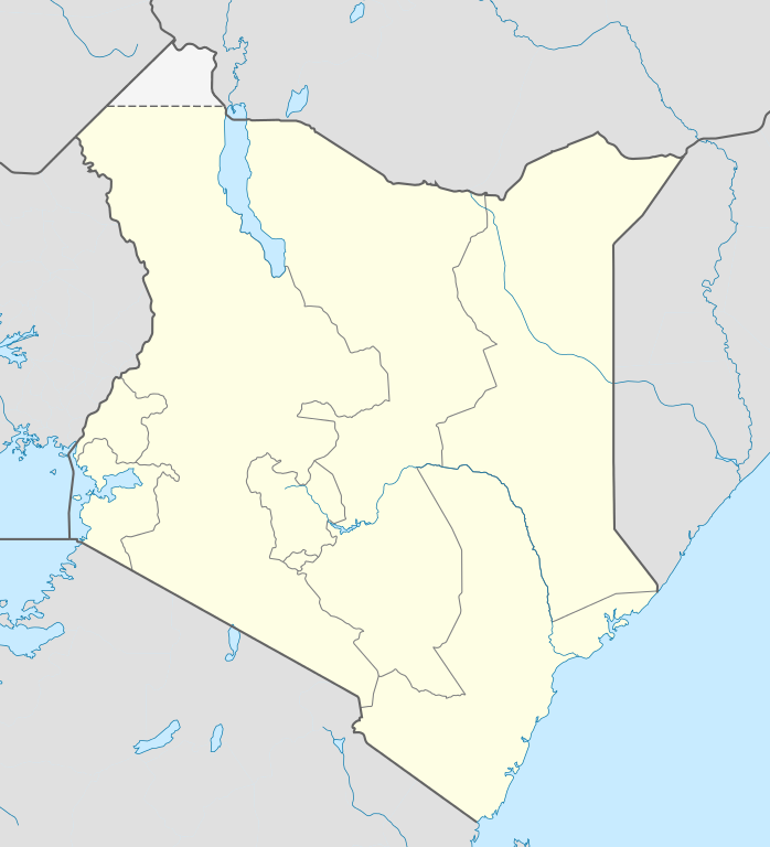
Deutsch: Location map of Kenya
Equirectangular projection. Strechted by 100.0%. Geographic limits of the map:
|
| Taariikhda | |
| Xigasho | Shaqadayda |
| Qoraa | Uwe Dedering |
| Other versions |
|

Laysinka
Uwe Dedering at Jarmal Wikipedia, the copyright holder of this work, hereby publishes it under the following licenses:

|
Permission is granted to copy, distribute and/or modify this document under the terms of the GNU Free Documentation License, Version 1.2 or any later version published by the Free Software Foundation; with no Invariant Sections, no Front-Cover Texts, and no Back-Cover Texts. A copy of the license is included in the section entitled GNU Free Documentation License. |
This file is licensed under the Creative Commons Attribution-Share Alike 3.0 Unported license.
Attribution: Uwe Dedering at Jarmal Wikipedia
- Waad fasaxantahay:
- la wadaagid – koobi gareenta, qaybinta iyo gudbinta shaqada
- to remix – in shaqada la waafajiyo
- Shuruudaha soo socda:
- Astaan – You must give appropriate credit, provide a link to the license, and indicate if changes were made. You may do so in any reasonable manner, but not in any way that suggests the licensor endorses you or your use.
- si isku mid la wadaag – If you remix, transform, or build upon the material, you must distribute your contributions under the same or compatible license as the original.
This file is licensed under the Creative Commons Attribution-Share Alike 3.0 Germany license.
Attribution: Uwe Dedering at Jarmal Wikipedia
- Waad fasaxantahay:
- la wadaagid – koobi gareenta, qaybinta iyo gudbinta shaqada
- to remix – in shaqada la waafajiyo
- Shuruudaha soo socda:
- Astaan – You must give appropriate credit, provide a link to the license, and indicate if changes were made. You may do so in any reasonable manner, but not in any way that suggests the licensor endorses you or your use.
- si isku mid la wadaag – If you remix, transform, or build upon the material, you must distribute your contributions under the same or compatible license as the original.

You may select the license of your choice.
Original upload log
Transferred from de.wikipedia to Commons by Uwe Dedering.
The original description page was here. All following user names refer to de.wikipedia.
- 2010-02-16 11:08 Uwe Dedering 1000×1200× (349329 bytes) {{Information |Beschreibung = Location map of Kenya Equirectangular projection. Strechted by 100.0%. Geographic limits of the map: * N: 7.0° N * S: -5.0° N * W: 33.0° E * E: 43.0° E Made with Natural Earth. Free vector and raster map data @ naturalearthdata.com. |Quelle = own work |Urheber = [[Benutzer:Uwe Dedering|Uwe Dedering]] |Datum = 20100216 |Genehmigung = |Andere Versionen = |Anmerkungen = }}
Taariikhda faylka
Riix taariikhda/waqtiga si aad u argto faylka sida oo ahaa markiisa hore.
| Taariikhda/Waqtiga | Sawir yar | Cabirka | Isticmaale | Ka hadalka | |
|---|---|---|---|---|---|
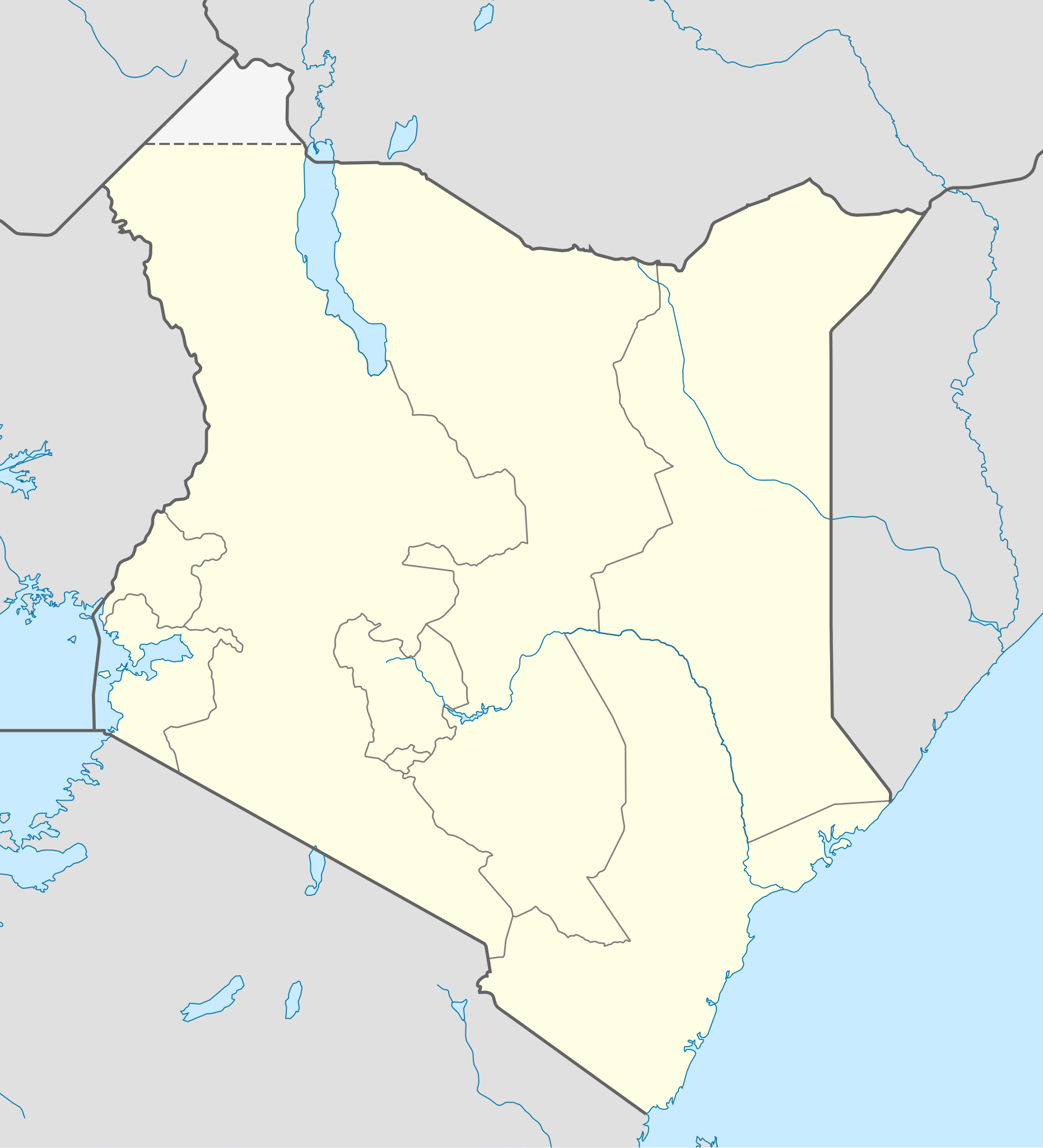
| kan hadda | 12:00, 17 Febraayo 2010 | | 1,000 × 1,100 (329 KB) | Uwe Dedering | regional boundaries only for kenya |
| 11:37, 17 Febraayo 2010 |  | 1,000 × 1,100 (368 KB) | Uwe Dedering | Northern limit now 6 degrees | |
| 21:52, 16 Febraayo 2010 |  | 1,000 × 1,200 (341 KB) | Uwe Dedering | {{Information |Description={{de|Location map of Kenya Equirectangular projection. Strechted by 100.0%. Geographic limits of the map: * N: 7.0° N * S: -5.0° N * W: 33.0° E * E: 43.0° E Made with Natural Earth. Free vector and raster map data @ naturale |
Faylka lagu isticmaalay
waxyaabaha soo socda ee bog ayaa adeegsanaya faylkaan:
isticmaalka faylka aduunka
Wikisyada kale ee soosocda ayaa adeegsanaya faylka:
- Ku isticmaal af.wikipedia.org
- Ku isticmaal als.wikipedia.org
- Ku isticmaal am.wikipedia.org
- Ku isticmaal ar.wikipedia.org
- Ku isticmaal arz.wikipedia.org
- Ku isticmaal az.wikipedia.org
- Ku isticmaal ba.wikipedia.org
- Ku isticmaal be-tarask.wikipedia.org
- Ku isticmaal be.wikipedia.org
- Ku isticmaal bg.wikipedia.org
- Ku isticmaal bn.wikipedia.org
- Ku isticmaal ceb.wikipedia.org
View more global usage of this file.