File:Jeddah map.png

Cabirka muuqaalkaan: 437 × 599 pixels. Waxyaabaha kale xalinta: 175 × 240 pixels | 350 × 480 pixels | 705 × 966 pixels.
Faylka asalka ah (705 × 966 pixels, weyninka faylka : 291 KB, nuuca MIME: image/png)
Qoraal kooban
| Sharaxaad |
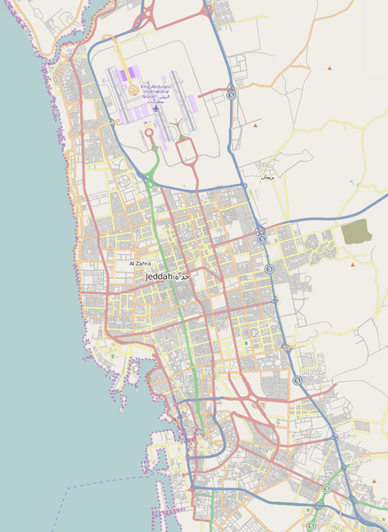
English: A map showing the main street of Jeddah, Saudi Arabia, with King Abdulaziz International Airport at the top. The two highways to Mecca (80 km) leave the map at the lower right-hand corner. |
| Taariikhda | |
| Xigasho | OpenStreetMap |
| Qoraa | Physchim62 using data from OpenStreetMap |
| Camera location | | View this and other nearby images on: OpenStreetMap |
|---|
Laysinka
This file is licensed under the Creative Commons Attribution-Share Alike 3.0 Unported license.
- Waad fasaxantahay:
- la wadaagid – koobi gareenta, qaybinta iyo gudbinta shaqada
- to remix – in shaqada la waafajiyo
- Shuruudaha soo socda:
- Astaan – You must give appropriate credit, provide a link to the license, and indicate if changes were made. You may do so in any reasonable manner, but not in any way that suggests the licensor endorses you or your use.
- si isku mid la wadaag – If you remix, transform, or build upon the material, you must distribute your contributions under the same or compatible license as the original.
Taariikhda faylka
Riix taariikhda/waqtiga si aad u argto faylka sida oo ahaa markiisa hore.
| Taariikhda/Waqtiga | Sawir yar | Cabirka | Isticmaale | Ka hadalka | |
|---|---|---|---|---|---|
| kan hadda | 16:47, 20 Jannaayo 2015 | | 705 × 966 (291 KB) | Kopiersperre | map updated |
| 07:23, 27 Nofeembar 2009 |  | 456 × 594 (143 KB) | Physchim62 | {{Information |Description={{en|1=A map showing the main street of w:Jeddah, w:Saudi Arabia, with w:King Abdulaziz International Airport at the top. The two highways to w:Mecca (80 km) leave the map at the lower right-hand corner.}} |S |
Faylka lagu isticmaalay
waxyaabaha soo socda ee bog ayaa adeegsanaya faylkaan:
isticmaalka faylka aduunka
Wikisyada kale ee soosocda ayaa adeegsanaya faylka:
- Ku isticmaal ca.wikipedia.org
- Ku isticmaal de.wikipedia.org
- Ku isticmaal en.wikipedia.org
- Ku isticmaal fa.wikipedia.org
- Ku isticmaal he.wikipedia.org
- Ku isticmaal id.wikipedia.org
- Ku isticmaal incubator.wikimedia.org
- Ku isticmaal ja.wikipedia.org
- Ku isticmaal ml.wikipedia.org
- Ku isticmaal ms.wikipedia.org
- Ku isticmaal mt.wikipedia.org
- Ku isticmaal mzn.wikipedia.org
- Ku isticmaal ne.wikipedia.org
- Ku isticmaal nn.wikipedia.org
- Ku isticmaal ru.wikipedia.org
- Ku isticmaal sat.wikipedia.org
- Ku isticmaal sl.wikipedia.org
- Ku isticmaal tg.wikipedia.org
- Ku isticmaal tl.wikipedia.org
- Ku isticmaal tr.wikipedia.org
- Ku isticmaal vep.wikipedia.org
- Ku isticmaal vi.wikipedia.org