File:Cocos(keeling) 76.jpg

Cabirka muuqaalkaan: 519 × 600 pixels. Waxyaabaha kale xalinta: 208 × 240 pixels | 415 × 480 pixels | 885 × 1,023 pixels.
Faylka asalka ah (885 × 1,023 pixels, weyninka faylka : 141 KB, nuuca MIME: image/jpeg)
_76.jpg)
Qoraal kooban
| Sharaxaad |
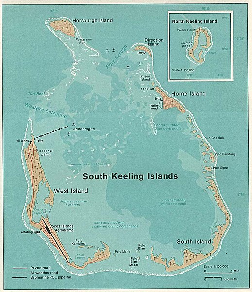
Deutsch: Karte der Kokos(Keeling)-Inseln im Indischen Ozean
English: Map of Cocos (Keeling) Islands in the Indian Ocean |
| Taariikhda | |
| Xigasho | http://www.lib.utexas.edu/maps/islands_oceans_poles/cocos(keeling)_76.jpg |
| Qoraa | Taken from Perry-Castañeda Library (PCL), originally from CIA Indian Ocean Atlas |
_76.jpg)
Laysinka
| This image is a work of a Central Intelligence Agency employee, taken or made as part of that person's official duties. As a Work of the United States Government, this image or media is in the public domain in the United States.
|

|
Taariikhda faylka
Riix taariikhda/waqtiga si aad u argto faylka sida oo ahaa markiisa hore.
| Taariikhda/Waqtiga | Sawir yar | Cabirka | Isticmaale | Ka hadalka | |
|---|---|---|---|---|---|
| kan hadda | 20:06, 5 Oktoobar 2006 | | 885 × 1,023 (141 KB) | Ratzer | http://www.lib.utexas.edu/maps/islands_oceans_poles/cocos(keeling)_76.jpg |
Faylka lagu isticmaalay
waxyaabaha soo socda ee bog ayaa adeegsanaya faylkaan:
isticmaalka faylka aduunka
Wikisyada kale ee soosocda ayaa adeegsanaya faylka:
- Ku isticmaal ar.wikipedia.org
- Ku isticmaal ca.wikipedia.org
- Ku isticmaal ceb.wikipedia.org
- Ku isticmaal cs.wikipedia.org
- Ku isticmaal cy.wikipedia.org
- Ku isticmaal de.wikipedia.org
- Ku isticmaal el.wikipedia.org
- Ku isticmaal en.wikipedia.org
- Ku isticmaal en.wikivoyage.org
- Ku isticmaal eo.wikipedia.org
- Ku isticmaal es.wikipedia.org
- Ku isticmaal et.wikipedia.org
- Ku isticmaal eu.wikipedia.org
- Ku isticmaal fa.wikipedia.org
- Ku isticmaal fi.wikipedia.org
- Ku isticmaal fr.wikipedia.org
- Ku isticmaal he.wikipedia.org
- Ku isticmaal hr.wikipedia.org
- Ku isticmaal id.wikipedia.org
- Ku isticmaal it.wikipedia.org
- Ku isticmaal ja.wikipedia.org
- Ku isticmaal ko.wikipedia.org
- Ku isticmaal lt.wikipedia.org
- Ku isticmaal ms.wikipedia.org
- Ku isticmaal ms.wiktionary.org
- Ku isticmaal nl.wikipedia.org
- Ku isticmaal no.wikipedia.org
- Ku isticmaal pl.wikipedia.org
View more global usage of this file.
_76.jpg)
_76.jpg)