File:Chechnya and Caucasus.png
Faah faahin dheeraad ah malahan.
Chechnya_and_Caucasus.png (550 × 296 pixels, weyninka faylka : 66 KB, nuuca MIME: image/png)
Qoraal kooban
| Sharaxaad |
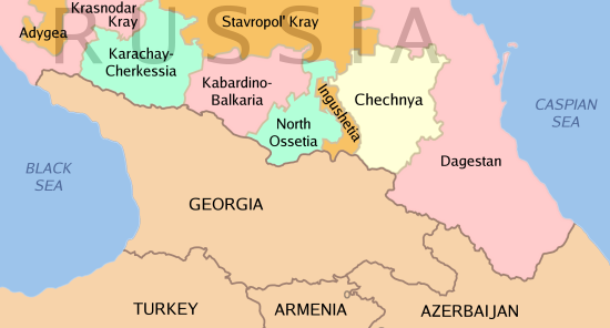
English: Map showing Chechnya's geographic relationship to the Caucasus region. |
| Taariikhda | |
| Xigasho | Shaqadayda |
| Qoraa | Kbh3rd |
| Other versions | Derivative works of this file: Caucasus Map Karta Kavkaza.jpg |

|
This locator map image could be re-created using vector graphics as an SVG file. This has several advantages; see Commons:Media for cleanup for more information. If an SVG form of this image is available, please upload it and afterwards replace this template with
{{vector version available|new image name}}.
It is recommended to name the SVG file “Chechnya and Caucasus.svg”—then the template Vector version available (or Vva) does not need the new image name parameter. |
Laysinka

|
Permission is granted to copy, distribute and/or modify this document under the terms of the GNU Free Documentation License, Version 1.2 or any later version published by the Free Software Foundation; with no Invariant Sections, no Front-Cover Texts, and no Back-Cover Texts. A copy of the license is included in the section entitled GNU Free Documentation License. |
| This file is licensed under the Creative Commons Attribution-Share Alike 3.0 Unported license. | ||
| ||
| This licensing tag was added to this file as part of the GFDL licensing update. |
Taariikhda faylka
Riix taariikhda/waqtiga si aad u argto faylka sida oo ahaa markiisa hore.
| Taariikhda/Waqtiga | Sawir yar | Cabirka | Isticmaale | Ka hadalka | |
|---|---|---|---|---|---|
| kan hadda | 16:32, 26 Febraayo 2022 | | 550 × 296 (66 KB) | AntiCompositeNumber | run pngfix per phab:T285875 |
| 05:15, 5 Febraayo 2005 |  | 550 × 296 (66 KB) | Kbh3rd | Map showing Chechnya's geographic relationship to the Caucasus region. {{GFDL}} |
Faylka lagu isticmaalay
waxyaabaha soo socda ee bog ayaa adeegsanaya faylkaan:
isticmaalka faylka aduunka
Wikisyada kale ee soosocda ayaa adeegsanaya faylka:
- Ku isticmaal ar.wikipedia.org
- Ku isticmaal ast.wikipedia.org
- Ku isticmaal azb.wikipedia.org
- Ku isticmaal az.wikipedia.org
- Ku isticmaal be-tarask.wikipedia.org
- Ku isticmaal be.wikipedia.org
- Ku isticmaal bg.wikipedia.org
- Ku isticmaal bn.wikipedia.org
- Ku isticmaal ca.wikipedia.org
- Ku isticmaal cs.wikipedia.org
- Ku isticmaal cy.wikipedia.org
- Ku isticmaal da.wikipedia.org
- Ku isticmaal de.wikipedia.org
- Ku isticmaal diq.wikipedia.org
- Ku isticmaal el.wikipedia.org
- Ku isticmaal en.wikipedia.org
- Second Chechen War
- Avars (Caucasus)
- User:Kbh3rd/Images
- Beslan school siege
- 2005 raid on Nalchik
- Talk:Chechen Republic of Ichkeria
- Insurgency in the North Caucasus
- Wikipedia:Top 25 Report/April 14 to 20, 2013
- Wikipedia:Top 25 Report/April 21 to 27, 2013
- Cossack Lullaby
- Wikipedia:WikiProject Women in Red/Meetup/162
- User:PurpleHaze2022/The Provisional Council of the Chechen Republic
- User:Dainomite/Geopolitical interests
- Islamic State insurgency in the North Caucasus
- Ku isticmaal en.wikibooks.org
- Ku isticmaal en.wiktionary.org
- Ku isticmaal eo.wikipedia.org
- Ku isticmaal es.wikipedia.org
- Ku isticmaal fa.wikipedia.org
- Ku isticmaal fi.wikipedia.org
View more global usage of this file.