Faylka asalka ah(SVG file, nominally 994 × 1,233 pixels, file size: 1.88 MB)

Faylkaan wuxuu ka socdaa Wikimedia Commons waxaana adeegsan kara mashaariic kale. Sharaxaadda ku taal boggeeda faylka ee bogga sharaxaadda faylka halkan hoose ayaa lagu muujiyey.

Sharaxaad
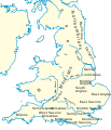
Deutsch: Landnahme der Angeln, Sachsen und Jüten auf den Britischen Inseln um das Jahr 600.
English: Peoples of Britain circa 600.
Español: Mapa da Bretanha ca. 600.
Français : La Grande-Bretagne vers 600.
Magyar: Brit népcsoportok 600 körül.
Polski: Ludy Brytanii ok. 600 r.
Português: Mapa da Bretanha ca. 600.
中文(中国大陆) 公元600年的不列颠。
Taariikhda
Xigasho

Own work using:

  • File:Britain peoples circa 600.png by User:IMeowbot
  • Border data: CIA
  • People locations: The Historical Atlas by William R. Shepherd, 1926 edition, with clarifications supplied by en:User:Everyking per references used in en:Penda of Mercia.
  • Anglo-Saxon coastline: Hill, 'An Atlas of Anglo-Saxon England' (1981) (the grey areas marked 'sea, swamp or alluvium' show where little Anglo-Saxon settlement occurred, because (according to Hill) there was at different periods either large areas of mud, marshland or open sea).
Qoraa User:Hel-hama
Ogolaasho
(Dib u isticmaalka faylkaan)
GNU head Permission is granted to copy, distribute and/or modify this document under the terms of the GNU Free Documentation License, Version 1.2 or any later version published by the Free Software Foundation; with no Invariant Sections, no Front-Cover Texts, and no Back-Cover Texts. A copy of the license is included in the section entitled GNU Free Documentation License.
w:en:Creative Commons
Astaan si isku mid la wadaag
This file is licensed under the Creative Commons Attribution-Share Alike 3.0 Unported license.
Waad fasaxantahay:
  • la wadaagid – koobi gareenta, qaybinta iyo gudbinta shaqada
  • to remix – in shaqada la waafajiyo
Shuruudaha soo socda:
  • Astaan – You must give appropriate credit, provide a link to the license, and indicate if changes were made. You may do so in any reasonable manner, but not in any way that suggests the licensor endorses you or your use.
  • si isku mid la wadaag – If you remix, transform, or build upon the material, you must distribute your contributions under the same or compatible license as the original.
This licensing tag was added to this file as part of the GFDL licensing update.
Other versions

[wax ka badal]

Captions

Add a one-line explanation of what this file represents

Items portrayed in this file

depicts Ingiriisi

copyright status Ingiriisi

copyrighted Ingiriisi

inception Ingiriisi

17 Juun 2012

MIME type Ingiriisi

image/svg+xml

checksum Ingiriisi

645226d666cacd3f1de8ccd88cbad0b708aafc4f

determination method Ingiriisi: SHA-1 Ingiriisi

data size Ingiriisi

1,972,631 byte

height Ingiriisi

1,233 pixel

width Ingiriisi

994 pixel

Taariikhda faylka

Riix taariikhda/waqtiga si aad u argto faylka sida oo ahaa markiisa hore.

Taariikhda/WaqtigaSawir yarCabirkaIsticmaaleKa hadalka
kan hadda16:03, 8 Luuliyo ama Luulyo 2012Sawirka yar nuuciisa ahaa 16:03, 8 Luuliyo ama Luulyo 2012994 × 1,233 (1.88 MB)Hel-hamacoastline and text modified
10:42, 17 Juun 2012Sawirka yar nuuciisa ahaa 10:42, 17 Juun 2012973 × 1,268 (4.16 MB)Hel-hamaRevised version of map using Shepherd's original version from http://www.lib.utexas.edu/maps/historical/history_shepherd_1923.html
20:58, 2 Sebteembar 2008Sawirka yar nuuciisa ahaa 20:58, 2 Sebteembar 2008944 × 1,104 (362 KB)Wereon{{Information |Description= |Source= |Date= |Author= |Permission= |other_versions= }}
20:57, 2 Sebteembar 2008Sawirka yar nuuciisa ahaa 20:57, 2 Sebteembar 2008944 × 1,104 (362 KB)Wereon. <!--{{ImageUpload|basic}}-->

waxyaabaha soo socda ee bog ayaa adeegsanaya faylkaan:

isticmaalka faylka aduunka

Metadata